Representative image. RC SRIKANTH, CC BY-SA 4.0, Wikimedia Commons

Why it matters
Andhra Pradesh is facing its second cyclone in about a week, and the IMD's surge warning covers low-lying coastal areas of Bapatla, Krishna and Prakasam. The heavy rain moving inland can also flood places in Telangana and Rayalaseema that the strongest winds never reach.
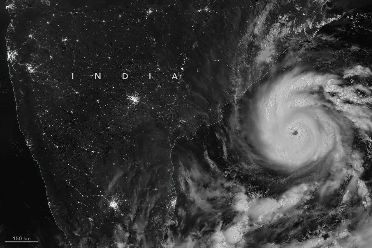
Cyclone Murasu landfall began close to Ongole in Andhra Pradesh’s Prakasam district at about 1 am on Tuesday, 3 November 2026, the India Meteorological Department (IMD) said, with sustained winds of 100 to 110 kmph and gusts up to 120 kmph. It is the second cyclone to hit the state in about a week, after Cyclone Arnab in late October.
In its 2.10 am release, quoted by The Hindu, the IMD said the storm’s inner rain band had entered south coastal Andhra Pradesh and its wall cloud, the ring of fierce wind and rain around the eye, was very close to the coast. The Times of India later reported, citing the IMD, that the eye had entered the coast and most of the wall cloud was over land. Officials told Chief Minister N Chandrababu Naidu at a 3.30 am review that the storm would finish crossing the coast by about 6.30 am, The Indian Express reported.
Where Cyclone Murasu landfall is happening and how strong it is
The IMD had forecast on Monday that Murasu, a severe cyclonic storm, would cross the south Andhra Pradesh coast between Nellore and Narsapur, to the south of Ongole, between 11.30 pm on 2 November and 4 am on 3 November. The landfall is taking place inside that window and that stretch of coast.
A landfall is not a single moment. It is the period during which the storm’s centre moves from sea to land, which can take several hours for a large system. The IMD expected the gale-force winds of 100 to 110 kmph to continue along and off the coast near the landfall point until morning.
Rain picked up before the eye arrived. Kothapatnam in Prakasam district had recorded 74.7 mm of rain by 1 am, while Ongole city had 18 mm, The Hindu reported. In Krishna district, many places had moderate rain between 11.30 pm and 1 am.
Early reports describe damage to trees rather than to the power network. The Indian Express reported that hundreds of trees were uprooted in Nellore, Prakasam and Bapatla districts and several low-lying areas were flooded, while electricity officials told the review meeting that no power poles had fallen and supply had not been disrupted in the affected areas.
How Murasu moved: a timeline from IMD bulletins
NewsPlainly put together the storm’s last 24 hours from the IMD’s own press release of 2 November and later bulletins as reported by The Hindu, India Today and The New Indian Express. Distances are the IMD’s; times are IST.
| Time (IST) | Where the centre was or what happened | Strength |
|---|---|---|
| 2.30 am, 2 Nov | Intensified into a severe cyclonic storm over the Bay of Bengal | Severe cyclonic storm |
| 8.30 am, 2 Nov | About 160 km east-southeast of Nellore and 210 km southeast of Ongole | 100 to 110 kmph, gusts 120 |
| 2.30 pm, 2 Nov | About 100 km east of Nellore | Same |
| 8.30 pm, 2 Nov | About 90 km southeast of Ongole, moving at 12 kmph | Same |
| About 1 am, 3 Nov | Landfall process began close to Ongole | 100 to 110 kmph, gusts 120 |
| 1.30 am, 3 Nov | About 40 km southeast of Ongole, 70 km south of Bapatla | Same |
The IMD’s forecast table in the same release shows how quickly the storm is expected to weaken over land: to a cyclonic storm with 70 to 80 kmph winds by 5.30 am on 3 November, a deep depression with 55 to 65 kmph by 5.30 pm the same day, and a depression with 35 to 45 kmph by 5.30 am on 4 November. These are forecasts, not measurements.
Storm surge, rain and wind warnings by district
The biggest danger near the coast is the storm surge, a rise in sea level pushed ashore by the cyclone’s winds. The IMD’s 2 November release warned of a surge of about 1.5 to 2 metres above the normal tide at landfall in south coastal Andhra Pradesh. Later bulletins reported by India Today and the Times of India put it at 1 to 1.5 metres. Both say the highest surge is expected in Bapatla, Krishna and Prakasam districts.
The IMD’s wind warning for the Andhra coast named nine districts: Krishna, Bapatla, Prakasam, Nellore (officially Sri Potti Sriramulu Nellore), Guntur, Eluru, NTR (the district around Vijayawada), Palnadu and West Godavari. For coastal Andhra Pradesh and Rayalaseema it forecast heavy to very heavy rain at a few places and extremely heavy rain at isolated places on 2 and 3 November.
The storm’s reach is wider than Andhra Pradesh. The same release forecast extremely heavy rain at isolated places in Telangana on 3 November, gale winds of up to 90 kmph in parts of Telangana and in Chittoor and Tirupati districts, and squally weather along the south Odisha coast in Malkangiri, Koraput, Rayagada, Gajapati and Ganjam.
Officials told the Chief Minister on Monday that Palnadu could get the most rain, around 30 cm, followed by Prakasam with 24 cm, India Today reported. Naidu asked officials to watch about 6,800 irrigation tanks in six districts for breaches.
Flights, fishing and help numbers in Andhra Pradesh
At least 19 domestic flights were cancelled at Vijayawada, Tirupati and Visakhapatnam airports on Monday, according to the Vijayawada airport director quoted by the Times of India. IndiGo cancelled 10 and Air India Express two at Vijayawada, with four cancellations at Visakhapatnam and three at Tirupati.
The IMD asked for a total halt to fishing. Its warning tells fishermen not to go out along and off the Andhra Pradesh coast until the afternoon of 4 November, and the west-central Bay of Bengal is closed to them until the same afternoon.
The state government has set up a WhatsApp line for cyclone problems such as fallen trees, power cuts, collapsed walls and flooding: send “Hi” to 9552300009, choose Services and then the Murasu cyclone option, the Times of India reported. The Hindu gave the same number, the state’s Mana Mitra service, for emergencies in Prakasam and other affected districts.
Six National Disaster Response Force (NDRF) teams and seven State Disaster Response Force (SDRF) teams had been deployed in the state, the Times of India reported, and three more NDRF teams with 90 personnel were sent from Tamil Nadu, The New Indian Express reported. At the night review, Naidu asked officials to keep people off the roads until fallen obstructions are cleared, The Indian Express reported. After Cyclone Arnab, at least five people died after touching fallen live wires, the same report said.
What the IMD expects next
The IMD’s action list for coastal Andhra Pradesh asks people in affected areas to stay indoors, people in huts near the coast to move to safer places, and everyone to avoid weak structures and roads that often flood. It warned of possible damage to thatched and kutcha houses, banana, papaya and coconut crops, and road and rail links.
Sea conditions along the Andhra coast are expected to start improving after the morning of 3 November and settle further by 4 November, according to the same release. The storm’s remnants are forecast to move inland and weaken over the next 24 hours, carrying rain into Telangana and Rayalaseema. Our earlier report on the Andhra Pradesh cyclone risk covered the forecast before landfall. The full forecast is in the IMD press release on Cyclone Murasu.
Frequently asked questions
Where did Cyclone Murasu make landfall?
Close to Ongole in Prakasam district, Andhra Pradesh, on the stretch between Nellore and Narsapur that the IMD had forecast. The process began at about 1 am on 3 November.
How strong is Cyclone Murasu?
It crossed as a severe cyclonic storm with winds of 100 to 110 kmph gusting to 120 kmph, according to the IMD. It is forecast to weaken quickly over land.
What is the Cyclone Murasu helpline number in Andhra Pradesh?
The state's WhatsApp line is 9552300009: send Hi, pick Services, then the Murasu cyclone option to report fallen trees, power cuts or flooding.
What does the name Murasu mean?
Murasu means war drum in Tamil. India proposed the name for the list used for storms in the region, The Indian Express reported.