
Representative image. RC SRIKANTH, CC BY-SA 4.0, Wikimedia Commons

Why it matters
The new track puts the Krishna delta coast, including Bapatla and Machilipatnam, in the landfall zone for the first time, and the storm is forecast one grade stronger. Families, farmers with crops ready for harvest and fishing communities there have about two days to prepare.
Cyclone Arnab is now expected to hit Andhra Pradesh harder and further south than first forecast. The weather system in the Bay of Bengal is likely to cross the coast between Bapatla and Visakhapatnam before noon on 28 October 2026 as a very severe cyclonic storm, with sustained winds of 115 to 125 kmph and gusts up to 140 kmph, the India Meteorological Department (IMD) said in its press release of 25 October. Odisha has shut schools in five southern districts and cancelled officers’ leave.
Where Cyclone Arnab is now and where it is heading
The low-pressure area turned into a depression, the first stage of a tropical storm, at 5.30 pm on 24 October. At 8.30 am on 25 October it sat over the east-central and south-east Bay of Bengal, about 880 km east-south-east of Visakhapatnam and 1,150 km east of Bapatla, according to the IMD’s 25 October press release.
The IMD expects it to drift south briefly and strengthen into a deep depression, then curve west-north-west. Its forecast steps are:
- cyclonic storm by the morning of 26 October;
- severe cyclonic storm over the west-central Bay around the morning of 27 October;
- very severe cyclonic storm near the Andhra Pradesh coast around the morning of 28 October;
- landfall between Bapatla and Visakhapatnam, including the Yanam coast, before noon on 28 October.
The name Arnab, proposed by Bangladesh, is used only once the system becomes a cyclonic storm, as NewsPlainly explained when the first warning came. A very severe cyclonic storm is the IMD’s grade for winds of 118 to 165 kmph, two steps above an ordinary cyclonic storm.
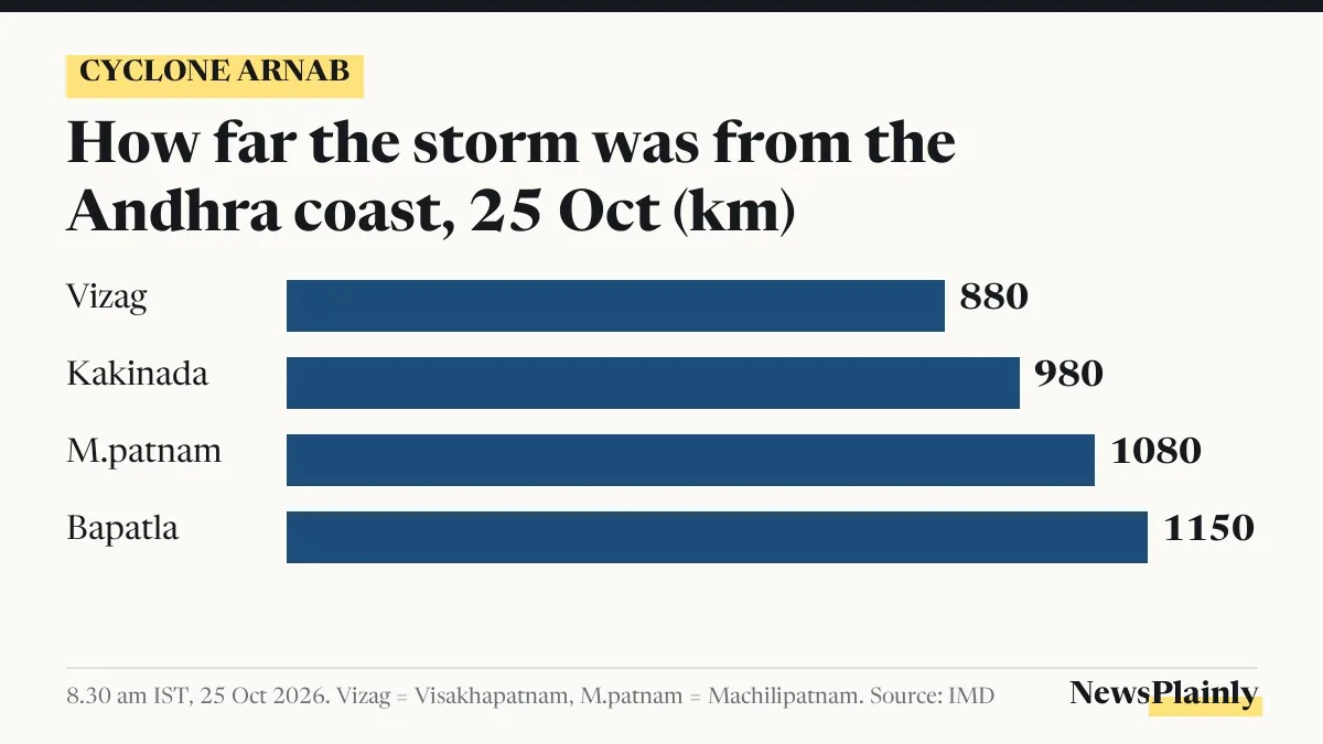
What changed in the Cyclone Arnab forecast since 23 October
Two days of tracking have moved the expected landfall and raised the strength. The table compares the IMD’s 23 October press release, the outlook given that day by the IMD’s Amaravati centre, and the IMD’s 25 October release.
| Point | 23 October forecast | 25 October forecast |
|---|---|---|
| Where it crosses | North Andhra and south Odisha coasts; Amaravati centre said anywhere from West Godavari to Srikakulam | Between Bapatla and Visakhapatnam, including Yanam |
| When | Early hours of 28 October (Amaravati centre) | Before noon on 28 October |
| Strength at landfall | “At least a severe cyclonic storm” (Amaravati centre) | Very severe cyclonic storm |
| Winds at landfall | Not given by the IMD; some models up to 145 kmph | 115 to 125 kmph, gusting to 140 kmph |
| Extremely heavy rain | North Andhra on 27 and 28 Oct; Odisha on 28 Oct | Coastal Andhra on 27 and 28 Oct; Odisha and Telangana on 28 Oct; Chhattisgarh on 28 and 29 Oct |
The biggest shift is southward. The new zone takes in Bapatla, Machilipatnam and the Krishna delta coast, south of the earlier West Godavari to Srikakulam range, and the storm is now forecast to be one grade stronger.
NewsPlainly’s district warning table of 24 October was based on the earlier track, so the district colours may change as the IMD issues new maps.
How strong the winds and sea will get
On land, squally winds of 40 to 50 kmph are expected along the Andhra Pradesh and Yanam coasts from the morning of 27 October. The IMD forecasts they will rise to 60 to 70 kmph by that afternoon, 90 to 100 kmph by the evening and 115 to 125 kmph, gusting to 140 kmph, by the morning of 28 October. After landfall they should ease to 70 to 80 kmph by the evening of 28 October.
The sea near the Andhra coast may reach “phenomenal” on the morning of 28 October, the IMD’s top grade, which its legend describes as waves higher than 14 metres in open sea. South Odisha and north Tamil Nadu coasts face squally weather of 40 to 50 kmph from the evening of 27 October to the evening of 28 October.
Fishermen have been told not to go into the west-central Bay from 26 to 28 October, or along and off the Andhra Pradesh and Odisha coasts on 27 and 28 October.

How Odisha and Andhra Pradesh are preparing
Odisha is not in the landfall zone, which is about 300 km from Gopalpur, the Press Trust of India (PTI) reported, but its southern districts are expected to get heavy rain and strong winds. Chief Minister Mohan Charan Majhi ordered schools, colleges and Anganwadi centres in Ganjam, Gajapati, Rayagada, Koraput and Malkangiri shut on 28 and 29 October, Hindustan Times reported. Those five districts are under a red warning for heavy to very heavy rain from 27 October, The Indian Express reported.
“Around 60 ODRAF teams and 17 NDRF teams have been deployed, while 225 Fire Services teams are on high alert,” Majhi said, according to The Indian Express. ODRAF is the Odisha Disaster Rapid Action Force and NDRF the National Disaster Response Force. The state has cancelled the leave of district collectors and officers in critical posts and told senior officials to stay at their headquarters from 26 October. Ganjam has readied 100 cyclone shelters and identified 1,000 temporary places to house people, its collector Keerthi Vasan V said, according to Hindustan Times.
In Andhra Pradesh, Prakhar Jain, managing director of the Andhra Pradesh State Disaster Management Authority (APSDMA), asked people to stay “extremely alert” as the system strengthens, PTI reported. The APSDMA helplines listed earlier are 112, 1070 and 18004250101.

What people in the path should do
The IMD’s 25 October release lists the steps it advises for the heavy rain and wind:
- watch the weather updates and be ready to move to a safe place if asked;
- take shelter in a safe building, never under trees, because of lightning;
- unplug electrical appliances when lightning is near and keep away from water bodies;
- farmers in coastal Andhra should harvest ready groundnut, maize, paddy and ragi when the weather is clear, store the produce safely, drain standing crops, and cover harvested crops with tarpaulin.
The IMD warns that kutcha houses, huts and weak structures may be damaged, trees and light objects may fall or fly, and road and rail traffic may be disrupted. Cyclone Arnab’s track can still shift, and the IMD issues new bulletins several times a day.
Frequently asked questions
Where will Cyclone Arnab make landfall?
The IMD expects it to cross the Andhra Pradesh and Yanam coasts between Bapatla and Visakhapatnam before noon on 28 October 2026.
How strong will Cyclone Arnab be?
A very severe cyclonic storm with sustained winds of 115 to 125 kmph and gusts up to 140 kmph at landfall, according to the IMD's 25 October press release.
Are schools closed in Odisha because of the cyclone?
Yes. Schools, colleges and Anganwadi centres in Ganjam, Gajapati, Rayagada, Koraput and Malkangiri are shut on 28 and 29 October, Hindustan Times reported.
Why is it called Cyclone Arnab before it forms?
Arnab is the next name on the list for the region. It is officially used only once the system becomes a cyclonic storm, expected by the morning of 26 October.