
Representative image. Srichakra Pranav, CC BY-SA 3.0, Wikimedia Commons

Why it matters
A cyclone on the Andhra Pradesh and Odisha coasts there can bring flooding, power cuts and disrupted trains and flights. Knowing the dates now gives families, farmers and fishermen a few days to prepare.
A Bay of Bengal cyclone could form by the morning of Monday, 26 October 2026, the India Meteorological Department (IMD) said on Friday, and it is expected to head for the coast between north Andhra Pradesh and south Odisha in the two days after that. A low-pressure area, a patch of falling air pressure that can grow into a storm, formed over the east-central and south-east Bay at 5.30 am on 23 October, an Odisha minister said, citing the IMD. If it strengthens as forecast, it will be named Cyclone Arnab.
How the Bay of Bengal cyclone is expected to grow
The IMD has laid out a step-by-step forecast. The low-pressure area is likely to stay over the same region and become a depression on Saturday, 24 October. It should then move west-northwest, deepen into a deep depression on 25 October and turn into a cyclonic storm over the west-central Bay of Bengal by the morning of 26 October, the weather office said in a special bulletin quoted by The Indian Express and The Hindu.
After that, the IMD expects the storm to keep strengthening as it moves towards the north Andhra Pradesh and adjoining south Odisha coasts over the following two days. The IMD has not yet said where or when it would cross the coast.
The name is already fixed. Under the list of names kept by the World Meteorological Organization (WMO) and the IMD for the North Indian Ocean, the next cyclone in the region will be called Arnab, a Bengali word for “ocean” put forward by Bangladesh, Hindustan Times reported. The Indian Express said it would be the first cyclone to form over the Bay of Bengal in 2026.

When heavy rain is due in Andhra Pradesh and Odisha
The rain warnings stretch over most of next week, and the reports give slightly different windows, so each is attributed here.
- 23 to 25 October: squally weather with light to moderate rain is likely over the Andaman Islands, coastal Odisha, coastal Andhra Pradesh and parts of Gangetic West Bengal, according to the IMD forecast reported by The Hindu.
- 26 and 27 October: very heavy rain is likely over coastal Odisha and the northern Nicobar Islands, The Indian Express reported.
- 27 to 29 October: heavy to extremely heavy rain is forecast for coastal Andhra Pradesh and Odisha, Hindustan Times reported, citing the IMD.
- Winds: gusts of up to 60 km/h are very likely along the Andhra Pradesh and Odisha coasts on 27 October and should pick up after that.
The south is already wet. With the northeast monsoon active, the IMD expects heavy rain to continue over Tamil Nadu, coastal Andhra Pradesh, Yanam, Rayalaseema, Kerala and coastal Karnataka until 27 October, and over north Karnataka until 25 October. NewsPlainly reported on 21 October that Tamil Nadu’s rain spell was set to last till 26 October, and that the outlook for the week after depended on this very system.

Depression, deep depression, cyclone: what the IMD stages mean
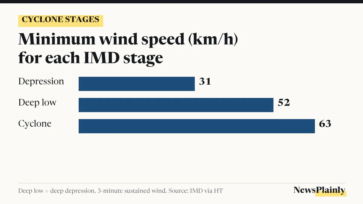
A low-pressure area is not yet a storm. The IMD grades these systems by how strong the winds blowing around them are, measured as the steady wind speed over three minutes at sea.
- Depression: 31 to 50 km/h (17 to 27 knots).
- Deep depression: 52 to 61 km/h (28 to 33 knots).
- Cyclonic storm: 63 km/h (34 knots) or more. Only at this stage does the system get a name.
On a weather map the same grades show up as rings of equal pressure, called isobars: one closed ring for a low, two for a depression, three for a deep depression and four or more for a cyclonic storm. So the system has to cross three thresholds in three days before it counts as Cyclone Arnab. The IMD calls this “very likely”, but it remains a forecast.
Last month showed how this can go. A system watched as a possible cyclone in September became a deep depression over the west-central Bay on 23 September but never reached cyclone strength. It still crossed the Andhra Pradesh and Odisha coast and brought heavy rain, Hindustan Times reported.
How Odisha is preparing for the Bay of Bengal cyclone
Odisha has started getting ready. “Keeping in view of the IMD message, the state government has already started preparations for the impending weather system that will approach the Odisha-Andhra Pradesh coasts,” Revenue and Disaster Management Minister Suresh Pujari said, according to The Hindu. The state has not yet announced evacuations or school closures.
The clearest instruction so far is for people at sea. The IMD has advised fishermen who are out in the Bay of Bengal to return to the coast by the morning of 24 October, before the depression forms.
The east coast faces this every year. Of about four cyclones that form over the North Indian Ocean in an average year, three form over the Bay of Bengal, according to The Indian Express. Official updates come from the IMD’s Regional Specialised Meteorological Centre for tropical cyclones in New Delhi, which issues bulletins several times a day once a depression forms.
Frequently asked questions
When will the Bay of Bengal cyclone form?
The IMD expects the low-pressure area to become a cyclonic storm by the morning of 26 October 2026, after becoming a depression on 24 October and a deep depression on 25 October.
What will the cyclone be called?
If it reaches cyclone strength it will be named Arnab, a Bengali word for ocean, from the list kept by the WMO and the IMD.
Which areas will get heavy rain?
Coastal Andhra Pradesh and Odisha, with heavy to extremely heavy rain forecast from 27 to 29 October. Tamil Nadu, Kerala and coastal Karnataka also have heavy rain forecast until 27 October.
Is it safe to go fishing?
No. The IMD has asked fishermen already at sea to return to the coast by the morning of 24 October.