
Representative image. KGKDeepak, CC BY-SA 4.0, Wikimedia Commons

Why it matters
The seven red-alert districts run from Visakhapatnam to the Godavari delta, and the IMD expects flooded roads, traffic disruption and crop damage there. Knowing which day each district is warned for gives families, farmers and fishing communities time to prepare before the storm arrives.
The Andhra cyclone now has a date. The weather system building in the Bay of Bengal is likely to cross the north Andhra Pradesh coast in the early hours of 28 October 2026, somewhere between West Godavari and Srikakulam districts, the head of the India Meteorological Department’s (IMD) Amaravati centre said. Red warnings for extremely heavy rain cover seven Andhra districts across 27 and 28 October, and fishermen have been told to stay off the sea.
Where the Andhra cyclone is likely to make landfall
Cyclone landfall is the moment a storm’s centre crosses from sea to land, when winds and rain are usually at their worst. K. Naga Ratna, who heads the Amaravati Meteorological Centre, told The Hindu that the system was likely to cross in the early hours of 28 October and move on towards Odisha the next day. She was careful about the exact spot. Some weather models point to Visakhapatnam, others to Kakinada and Konaseema, and the crossing could come anywhere along the stretch from West Godavari to Srikakulam, she said.
IMD Director General Mrutyunjay Mohapatra gave the same morning of 28 October, placing the landfall between the north Andhra Pradesh and south Odisha coasts, according to a report by the Press Trust of India (PTI) news agency carried by OrissaPOST.
On strength, Naga Ratna said the storm would be “at least a severe cyclonic storm”, and that some models show a very severe cyclonic storm with winds of up to 145 kmph and a storm surge of 1 to 2 metres. A storm surge is a rise in sea level pushed onshore by the wind, which floods low-lying coastal land. A severe cyclonic storm is the third of the IMD’s storm grades, explained further below.

How the Bay of Bengal system is expected to build, day by day
The IMD’s press release of 23 October lays out the steps. A low-pressure area, a patch of falling air pressure that can grow into a storm, formed over the east-central and adjoining south-east Bay of Bengal at 5.30 am on 23 October. The IMD expects it to:
- become a depression on 24 October;
- move west-northwest and turn into a deep depression on 25 October;
- become a cyclonic storm over the west-central Bay of Bengal by the morning of 26 October;
- keep strengthening for the next two days as it heads for the north Andhra Pradesh and south Odisha coasts.
Once it reaches cyclonic storm strength it will take the next name on the list for the region, Arnab, as NewsPlainly reported on 23 October. The IMD said its next press release would come at 2.30 pm on 24 October, so the timing and place of the cyclone landfall may still shift.
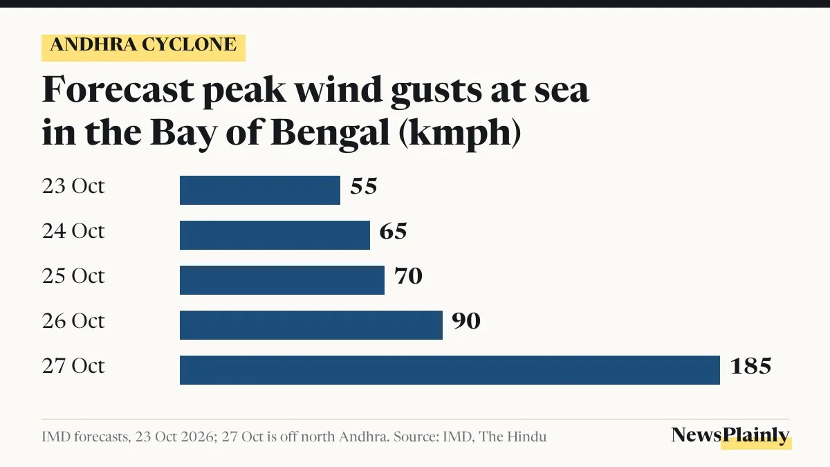
Winds at sea are forecast to rise steadily. The release puts gusts at 55 kmph on 23 October, 65 kmph on 24 October, 70 kmph on 25 October and 90 kmph by the morning of 26 October. The IMD’s sea warning for 27 October is far higher: 120 to 165 kmph, gusting to 185 kmph, off the north Andhra coast, The Hindu reported. On land, squally winds of 40 to 50 kmph, gusting to 60 kmph, are expected along the Andhra Pradesh and Odisha coasts from 27 October.
Andhra cyclone red warnings by district and date
The IMD uses colours for action. Red means take action, orange means be prepared, and yellow means stay updated. The table below brings together the district maps issued by the Amaravati centre on 23 October, as reported by The Hindu, and the Odisha warnings announced by the state’s disaster management minister.
| Date | Red (extremely heavy rain) | Orange (heavy to very heavy) | Yellow (heavy rain) |
|---|---|---|---|
| 27 Oct, Andhra | Visakhapatnam, Anakapalli | Srikakulam, Parvathipuram-Manyam, Vizianagaram, Eluru, Krishna | None listed |
| 28 Oct, Andhra | Alluri Sitharama Raju, Anakapalli, Kakinada, East Godavari, Konaseema, West Godavari | Visakhapatnam, Srikakulam, Parvathipuram-Manyam, Vizianagaram, Eluru, Krishna | None listed |
| 29 Oct, Andhra | None listed | None listed | Srikakulam, Parvathipuram-Manyam, Vizianagaram, Alluri Sitharama Raju |
| 27 Oct, Odisha | Puri, Ganjam, Gajapati (red zone) | Rain alerts for Bhadrak, Kendrapada, Jagatsinghpur, Mayurbhanj, Baleshwar, Kendujhar, Rayagada, Koraput, Malkangiri, Kalahandi | |
Anakapalli is the one district under red warnings on both days. Across the wider region, the IMD release expects extremely heavy rain at isolated places over north Andhra Pradesh on 27 and 28 October and over Odisha on 28 October, with heavy rain spreading to coastal West Bengal, Jharkhand, Chhattisgarh and Bihar on 28 and 29 October.
The rain has already begun further south. Amalapuram in Konaseema district recorded 94 mm and Nellore 73 mm in the 24 hours to 8.30 am on 23 October, The Hindu reported.

What people under red warnings are told to do
These steps come from the IMD’s “action suggested” list and the state disaster authorities. None of them is new advice from NewsPlainly.
- Fishermen: boats at sea were to be back on shore by the morning of 24 October. The IMD has asked them not to go into the east-central and south-east Bay until 26 October, the west-central Bay from 26 to 28 October, or along and off the Andhra Pradesh and Odisha coasts from 27 October.
- Everyone in the warned districts: the IMD advises avoiding areas that often flood, not staying in weak or unsafe buildings, checking traffic before setting out and following local traffic advisories.
- Farmers: the IMD expects damage to horticulture and standing crops from waterlogging, and the Andhra Pradesh State Disaster Management Authority (APSDMA) has asked farmers and the public to take precautions.
- Help: the APSDMA helplines are 112, 1070 and 18004250101, according to The Hindu.
The IMD also lists what heavy rain usually brings: flooded roads, closed underpasses, poor visibility, slower traffic in cities and damage to kutcha (unpaved) roads.
Odisha has put all its districts on alert and is concentrating on 16 coastal ones, Disaster Management Minister Suresh Pujari told reporters, according to OrissaPOST. Collectors have been told to move people out of low-lying areas and keep cyclone shelters ready, and pregnant women close to their due dates in vulnerable areas are to be shifted early to shelters or hospitals. Teams of the National Disaster Response Force (NDRF) and Odisha’s own rapid action force are on standby.
Why 28 October is a familiar cyclone landfall date on this coast
The north Andhra coast faced a similar run of warnings almost exactly a year ago. On 28 October 2025, Cyclone Montha, a severe cyclonic storm that had formed over the Bay of Bengal, was about 60 km from Machilipatnam and closing in on the Andhra Pradesh coast with winds of 90 to 100 kmph, and the IMD had issued red alerts for 19 coastal districts, All India Radio reported at the time.
The IMD grades storms by wind speed. In the legend of its fishermen’s warning map, a cyclonic storm brings gales of 60 to 80 kmph, a severe cyclonic storm 90 to 110 kmph and a very severe cyclonic storm 120 to 165 kmph. If the models Naga Ratna described are right, this system would sit in the upper part of that range at landfall.
The forecast still has three days to run, and the IMD is updating it twice a day. Where the Andhra cyclone crosses is the biggest open question, and it decides which of the districts in the table above take the heaviest blow.
Frequently asked questions
When will the Andhra cyclone make landfall?
The IMD's Amaravati centre expects it to cross the north Andhra Pradesh coast in the early hours of 28 October 2026, and then move towards Odisha on 29 October.
Which districts are on red alert in Andhra Pradesh?
Visakhapatnam and Anakapalli on 27 October; Alluri Sitharama Raju, Anakapalli, Kakinada, East Godavari, Konaseema and West Godavari on 28 October.
How strong will the cyclone be?
The IMD's Amaravati head said it would be at least a severe cyclonic storm, and some models show a very severe cyclonic storm with winds of up to 145 kmph.
What is the APSDMA helpline number?
The Andhra Pradesh State Disaster Management Authority lists 112, 1070 and 18004250101.